
Well, considering that New Orleans could be completely knocked off the face of the map within the next three days, I'll dedicate a thread to tracking, watching and informing those of you who care about what's going on in the tropics currently.
Two days ago marked the three year anniversary of hurricane Katrina's landfall upon the U.S. I don't find it ironic, per-say, that Gustav is relatively close in terms of unleashing his onslaught upon the "almighty country" as did Katrina three years prior; In the meteorological season, September is the prime month for tropical activity. However, unlike three years ago when I was sitting at home recovering from my head injuries, getting worked up and probably causing enough stress on my sinuses to re-fracture them due to FEMA and government not taking the proper precautions during the well noticeable NHC (National Hurricane Center) advisories and warnings, I feel a bit of comfort that Louisiana had declared a state of emergency well over 72 hours out from the projected landfall upon the state. Unlike with Katrina, residents of the gulf coast have a different and more, "safe", if you will, perspective upon handling evacuations. A tad bit of information that I'll share with you guys that I've heard from reading different articles and listening to actual Katrina survivors.
When Katrina hit, many people did not evacuate for two main reasons. Despite one sounding a bit "far-fetched", it's still plausible in their perspective, which is what counts. One, pets. Yes, many people left their lives in the hands of the beast because they did not want to leave their pets behind. Two, government paychecks. People did not have the money to evacuate because when Katrina had hit it fell a week before many poverty stricken families receive their checks from the government. Unlike Katrina, both of these previous causes of non-evacuation actions are covered this time. Many insurance policies, shelters and other institutions now have made pet allowances in their policies and laws. Shelters are able to support and care for pets, thus, people will leave their homes. This is one thing that has me a bit optimistic. Now, for the other information, which basically is all terrible. Lol.
We'll start with Gustav.
Monday, August 25th, 11AM: Tropical Depression number 7 formed in the Caribbean. Winds are at 35mph with the pressure at 1001mb, roughly.

Tuesday, August 26th: 5 AM, Tropical Depression number 7 is upgraded to Hurricane Gustav, with peak sustained winds at ~90mph and a central pressure reading at 984 mb.
Wednesday, August 27th: 5 AM, Hurricane Gustav is downgraded to a tropical storm due to the high elevations of Haiti tearing apart convection. Peak sustained winds are now at 60mph~, with a pressure at 998mb. Gustav has slowed down and dumped a good deal of rain over Haiti, striking dangerous mudslides and wide-spread flooding. Almost 60 lives were claimed in Haiti.
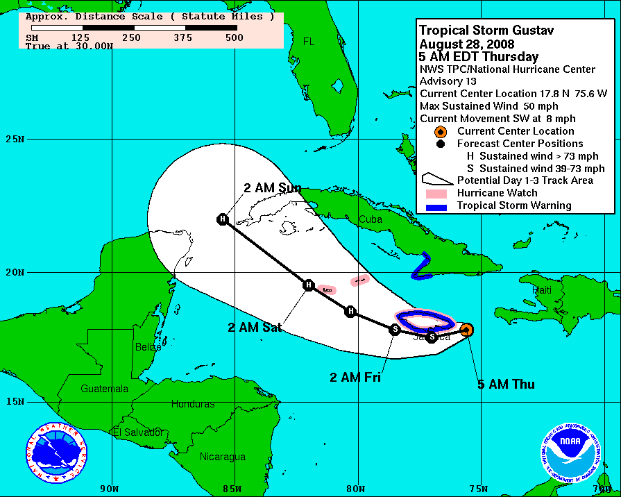
Thursday, August 28th, 5AM: Gustav is still a tropical storm with winds slightly increased due to moving off-shore of Haiti. Gustav made a plunge southward due to an upper level low forming northeast of Florida. Winds slightly increased, at around 70mph~ with an estimated pressure at 988mb. A ten millibar drop in a matter of hours from moving away from land. Gustav was forcasted from here to interact with Jamaica within the next 24 hours.
Friday, August 29th, 5AM: Not much has changed with Gustav. Interaction with Jamaica has prohibited development. However, it is forcasted that once upon entering ocean waters again, intensification is very favorable due to light upper level winds, warm ocean temperatures and no interaction with land within the next 30 hours. Gustav's previous winds and pressure are estimated being the same.
Saturday, August 30th, 5AM: Will excerpt a piece straight from the NWS/NHC advisory forecast discussion:
ZCZC MIATCDAT2 ALL
TTAA00 KNHC DDHHMM
HURRICANE GUSTAV DISCUSSION NUMBER 22
NWS TPC/NATIONAL HURRICANE CENTER MIAMI FL AL072008
500 AM EDT SAT AUG 30 2008
GUSTAV HAS BEEN RAPIDLY INTENSIFYING DURING THE OVERNIGHT HOURS.
SATELLITE IMAGES INDICATE THAT AN EYE IS BECOMING VISIBLE AND DEEP
CONVECTION SURROUNDING THE EYE IS NOW VERY INTENSE. THE CENTRAL
PRESSURE IS DOWN TO 965 MB...A DROP OF ABOUT 24 MB IN 24 HOURS. THE
MAXIMUM FLIGHT LEVEL WINDS REPORTED BY THE AIR FORCE CREW WERE 100
KT AROUND 6Z... CORRESPONDING TO ABOUT 90 KT AT THE SURFACE.
HOWEVER THE SATELLITE PRESENTATION HAS CONTINUED TO IMPROVE...THUS
THE INITIAL INTENSITY IS INCREASED CONSERVATIVELY TO 95 KT.
OBJECTIVE DVORAK T-NUMBERS ARE MUCH HIGHER AND THE NEXT AIRCRAFT
PASS THROUGH GUSTAV COULD FIND A MAJOR HURRICANE.
$$
FORECASTER BLAKE/AVILA

Over the next two hours, from 5AM, to 7AM, Gustav drops 6mb in 2 hours. Winds are now estimated at 130mph, making Gustav a category 3 hurricane; A major one.
A bit more information about this, because it really is significant.
Rapid intensification occurs when hurricanes undergo serious development within a 30 hour time-frame.
Such conditions for this are almost rare; needing very warm ocean temperatures, no winds aloft or verticle
sheer, and no interaction with land. Gustav, in fact, dropped 30mb of pressure within 30 hours, (could be even more)
thus, classifying this hurricane under this category for it's history. This is pretty sensational in meteorological terms, there
are only about 30 or so hurricanes in the history of record keeping have had a more rapid deepening than Gustav.
Just thought I'd throw that out there. Anyway, where was I..
Saturday, August 30th, 11PM: During the mid-day hours, Gustav becomes a category-4 hurricane, with winds sustained
within the eye wall at 150mph. Central pressure drops to 942mb, and looks as if it's still intensifying. Through, as the time
progresses, so does Gustav's movement towards Cuba. Gustav makes landfall upon Cuba several hours prior. Damage reports
aren't completely full yet, so I'm not going to list anything as of yet. I can say several stations in Cuba reported sustained winds of
120mph sustained winds, with gusts up to 142 mph. Of course, there may have been much higher sustained winds
and gusts in the north-eastern quadrant of the hurricane (the strongest), but I haven't seen any reports. Since Cuba's
topography isn't anything like Haitis; Cuba has relatively no mountain ranges (at least where landfall was made)
the toll on the hurricane isn't much. Sustained winds at around 145mph with a central pressure of 152~mb.
Also, just for those who don't know, I'll clip the Saffir-Simpson scale, or, measure of intensity/power a hurricane has,
here.
Saffir-Simpson Hurricane Scale
Category 5 ≥156 mph
Category 4 131�155 mph
Category 3 111�130 mph
Category 2 96�110 mph
Category 1 74�95 mph
Just for note: A category 5 landfall is catastrophic. There has only been 3 accurate landfalls to the U.S in history.
Current: August 31st, 5AM: Gustav took a bit more than expected weakening from Cuba's interaction. Patial eye-
wall covering has occurred and sustained winds now have dropped to around 140mph. Apparently, and definitely
temporary, Gustav has weakened. But it is far from over. Here's where the fun (but really horrific due to the nature of this hurricane
making landfall) comes in hurricane watching.
I'll begin with something called the loop current.
The loop current, in laments terms (I really don't feel like going in to the whole explanation behind it, it's 6:11 am =p),
is an area in the Gulf of Mexico that contains the deepest and warmest waters. Here's in an image of the loop current during
hurricane Katrina's path towards the U.S. (Note: The loop never really varies much, due to the depth of the ocean being stationary,
but warmer waters will vary in location from year to year. This map is currently close to what is accurate this year)

Alright. While this map does not show actual temperatures, it's accurate in terms of where the warmest waters are due to
Sea height and temperature are directly connected. It's safe to say that the areas of the warmest 27N to 93W
27N/22N-82W. Now let's look at Gustav's projected model guidance path currently.

Quite astonishing, eh? Gustav will continue to intensify the entire path until the gulf-reef, right before landfall,
where waters aren't as deep or warm. So, where can we expect, what can we expect, Gustav to do?
I can't specifically make my own forecast because I don't have the resources, models, or knowledge to at this point, so I'll include
the NWS/NHC's projected forecast, which is based off of model guidance and expert analysis. The image above is the current 3 day cone
projected forecast, giving Gustav a landfall just west of New Orleans. What does that mean?
Alright, some more information. When Katrina made landfall three years ago, it had landed to the east of New Orleans. Image:

Due to the nature of the counter-clockwise, anti-cyclonic spinning of a hurricane, winds forces tidal surge and water up the delta of the MS river. Lake Pontchartrain overflowed,
and with the excess water, broke the levees built to protect the below-sea-level town, leading to the total destruction Katrina is known for. Overall, Katrina's wind and intensity
had nothing to do with the destructive, infamous name it's spoken with; it was the location of landfall.
Now, with Gustav projected to be a Category 3+ (Most likely a mid-category 4 hurricane, winds ~145mph) upon landfall, which is stronger than Katrina was, and west of New Orleans,
you would think that history wouldn't repeat itself, correct? Wrong. For many reasons, actually.
A) The projected path is always subject to change; the obvious.
B) New Orleans, if the path is correct, will be forecasted to be in the North-East quadrant of the hurricane, which I stated before, is and will be always the most powerful. The current
projected path has the eye close enough to give NO a glancing blow with winds and rain, which could cause the same problems all over again.
C) This could be even worse, considering the western landfall now completely lays the highest surge upon NO's area. Image for probability:

While we still have time to embrace for the actual event, everyone along the gulf coast should still be taking their procedures upon evacuating and preparing; This will be a significant hurricane.
Just some more images for aesthetic purposes ;D


Anyway, on to another subject: Hannah.
I will not go in-depth on this storm as of yet, but I will include updates in the thread as it progresses.
Hanna is currently getting torn apart by an upper level low, sitting off the coast of Florida. Here's some images:


Hanna is in much interest to watch. Despite being torn apart by the upper level low, Hanna continues to push forward, and in-fact,
is now tearing the upper level low apart, which would lead to once again intensification. It's projected path over the last few days has
also changed drastically. Model guidance now suggest the Bermuda high to push off to the east, allowing Hanna to ride the east coast
compared to three days ago, where model guidance suggested Hanna push off to the south, tear through the middle of Cuba, where
Hanna would follow Gustav and deliver a second-punch making landfall in Louisiana a few days after Gustav's reign. Show's how much a
few days can drastically change things. ;D
Anyway, all eyes on the eastern seaboard should follow this storm as well. If what is suggested, Hanna could reach hurricane strength
within the next few days and head for Florida, The Carolinas, and up the eastern seaboard towards the Northeast region. I'll keep you updated on
that as well. Meanwhile, here's the current projected path as of 5AM:

This should make things very interesting over the next few weeks.
Anyway, oh wait----.. not done yet. o_o

The orange circled number 2 area, could very well develop into Ike, sometime in the near future.
The number one area is currently undergoing high sheer and is having a hard time to develop any
tropical features. Model guidance suggest Area 2 will move west northwestward over the next few days,
bringing it back into the region that Gustav just tore up. Will keep an eye out on that too.
Alright, that about concludes my (tl;dr post for some) write up, and I honestly hope everything goes
for the better where Gustav makes his landfall. Hopefully this gave you guys some information, and hopefully
I'll continue these types of posts with any type of significant weather effecting the world.
Edit: For those who want to know, my own personal feelings is that Gustav will roughly be around 130~mph landfall, in central Louisiana. I honestly don't expect it to keep the strength it has or will have the entire way. But hey, that's just me.
Two days ago marked the three year anniversary of hurricane Katrina's landfall upon the U.S. I don't find it ironic, per-say, that Gustav is relatively close in terms of unleashing his onslaught upon the "almighty country" as did Katrina three years prior; In the meteorological season, September is the prime month for tropical activity. However, unlike three years ago when I was sitting at home recovering from my head injuries, getting worked up and probably causing enough stress on my sinuses to re-fracture them due to FEMA and government not taking the proper precautions during the well noticeable NHC (National Hurricane Center) advisories and warnings, I feel a bit of comfort that Louisiana had declared a state of emergency well over 72 hours out from the projected landfall upon the state. Unlike with Katrina, residents of the gulf coast have a different and more, "safe", if you will, perspective upon handling evacuations. A tad bit of information that I'll share with you guys that I've heard from reading different articles and listening to actual Katrina survivors.
When Katrina hit, many people did not evacuate for two main reasons. Despite one sounding a bit "far-fetched", it's still plausible in their perspective, which is what counts. One, pets. Yes, many people left their lives in the hands of the beast because they did not want to leave their pets behind. Two, government paychecks. People did not have the money to evacuate because when Katrina had hit it fell a week before many poverty stricken families receive their checks from the government. Unlike Katrina, both of these previous causes of non-evacuation actions are covered this time. Many insurance policies, shelters and other institutions now have made pet allowances in their policies and laws. Shelters are able to support and care for pets, thus, people will leave their homes. This is one thing that has me a bit optimistic. Now, for the other information, which basically is all terrible. Lol.
We'll start with Gustav.
Monday, August 25th, 11AM: Tropical Depression number 7 formed in the Caribbean. Winds are at 35mph with the pressure at 1001mb, roughly.
Tuesday, August 26th: 5 AM, Tropical Depression number 7 is upgraded to Hurricane Gustav, with peak sustained winds at ~90mph and a central pressure reading at 984 mb.
Wednesday, August 27th: 5 AM, Hurricane Gustav is downgraded to a tropical storm due to the high elevations of Haiti tearing apart convection. Peak sustained winds are now at 60mph~, with a pressure at 998mb. Gustav has slowed down and dumped a good deal of rain over Haiti, striking dangerous mudslides and wide-spread flooding. Almost 60 lives were claimed in Haiti.
Thursday, August 28th, 5AM: Gustav is still a tropical storm with winds slightly increased due to moving off-shore of Haiti. Gustav made a plunge southward due to an upper level low forming northeast of Florida. Winds slightly increased, at around 70mph~ with an estimated pressure at 988mb. A ten millibar drop in a matter of hours from moving away from land. Gustav was forcasted from here to interact with Jamaica within the next 24 hours.
Friday, August 29th, 5AM: Not much has changed with Gustav. Interaction with Jamaica has prohibited development. However, it is forcasted that once upon entering ocean waters again, intensification is very favorable due to light upper level winds, warm ocean temperatures and no interaction with land within the next 30 hours. Gustav's previous winds and pressure are estimated being the same.
Saturday, August 30th, 5AM: Will excerpt a piece straight from the NWS/NHC advisory forecast discussion:
ZCZC MIATCDAT2 ALL
TTAA00 KNHC DDHHMM
HURRICANE GUSTAV DISCUSSION NUMBER 22
NWS TPC/NATIONAL HURRICANE CENTER MIAMI FL AL072008
500 AM EDT SAT AUG 30 2008
GUSTAV HAS BEEN RAPIDLY INTENSIFYING DURING THE OVERNIGHT HOURS.
SATELLITE IMAGES INDICATE THAT AN EYE IS BECOMING VISIBLE AND DEEP
CONVECTION SURROUNDING THE EYE IS NOW VERY INTENSE. THE CENTRAL
PRESSURE IS DOWN TO 965 MB...A DROP OF ABOUT 24 MB IN 24 HOURS. THE
MAXIMUM FLIGHT LEVEL WINDS REPORTED BY THE AIR FORCE CREW WERE 100
KT AROUND 6Z... CORRESPONDING TO ABOUT 90 KT AT THE SURFACE.
HOWEVER THE SATELLITE PRESENTATION HAS CONTINUED TO IMPROVE...THUS
THE INITIAL INTENSITY IS INCREASED CONSERVATIVELY TO 95 KT.
OBJECTIVE DVORAK T-NUMBERS ARE MUCH HIGHER AND THE NEXT AIRCRAFT
PASS THROUGH GUSTAV COULD FIND A MAJOR HURRICANE.
$$
FORECASTER BLAKE/AVILA
Over the next two hours, from 5AM, to 7AM, Gustav drops 6mb in 2 hours. Winds are now estimated at 130mph, making Gustav a category 3 hurricane; A major one.
A bit more information about this, because it really is significant.
Rapid intensification occurs when hurricanes undergo serious development within a 30 hour time-frame.
Such conditions for this are almost rare; needing very warm ocean temperatures, no winds aloft or verticle
sheer, and no interaction with land. Gustav, in fact, dropped 30mb of pressure within 30 hours, (could be even more)
thus, classifying this hurricane under this category for it's history. This is pretty sensational in meteorological terms, there
are only about 30 or so hurricanes in the history of record keeping have had a more rapid deepening than Gustav.
Just thought I'd throw that out there. Anyway, where was I..
Saturday, August 30th, 11PM: During the mid-day hours, Gustav becomes a category-4 hurricane, with winds sustained
within the eye wall at 150mph. Central pressure drops to 942mb, and looks as if it's still intensifying. Through, as the time
progresses, so does Gustav's movement towards Cuba. Gustav makes landfall upon Cuba several hours prior. Damage reports
aren't completely full yet, so I'm not going to list anything as of yet. I can say several stations in Cuba reported sustained winds of
120mph sustained winds, with gusts up to 142 mph. Of course, there may have been much higher sustained winds
and gusts in the north-eastern quadrant of the hurricane (the strongest), but I haven't seen any reports. Since Cuba's
topography isn't anything like Haitis; Cuba has relatively no mountain ranges (at least where landfall was made)
the toll on the hurricane isn't much. Sustained winds at around 145mph with a central pressure of 152~mb.
Also, just for those who don't know, I'll clip the Saffir-Simpson scale, or, measure of intensity/power a hurricane has,
here.
Saffir-Simpson Hurricane Scale
Category 5 ≥156 mph
Category 4 131�155 mph
Category 3 111�130 mph
Category 2 96�110 mph
Category 1 74�95 mph
Just for note: A category 5 landfall is catastrophic. There has only been 3 accurate landfalls to the U.S in history.
Current: August 31st, 5AM: Gustav took a bit more than expected weakening from Cuba's interaction. Patial eye-
wall covering has occurred and sustained winds now have dropped to around 140mph. Apparently, and definitely
temporary, Gustav has weakened. But it is far from over. Here's where the fun (but really horrific due to the nature of this hurricane
making landfall) comes in hurricane watching.
I'll begin with something called the loop current.
The loop current, in laments terms (I really don't feel like going in to the whole explanation behind it, it's 6:11 am =p),
is an area in the Gulf of Mexico that contains the deepest and warmest waters. Here's in an image of the loop current during
hurricane Katrina's path towards the U.S. (Note: The loop never really varies much, due to the depth of the ocean being stationary,
but warmer waters will vary in location from year to year. This map is currently close to what is accurate this year)
Alright. While this map does not show actual temperatures, it's accurate in terms of where the warmest waters are due to
Sea height and temperature are directly connected. It's safe to say that the areas of the warmest 27N to 93W
27N/22N-82W. Now let's look at Gustav's projected model guidance path currently.
Quite astonishing, eh? Gustav will continue to intensify the entire path until the gulf-reef, right before landfall,
where waters aren't as deep or warm. So, where can we expect, what can we expect, Gustav to do?
I can't specifically make my own forecast because I don't have the resources, models, or knowledge to at this point, so I'll include
the NWS/NHC's projected forecast, which is based off of model guidance and expert analysis. The image above is the current 3 day cone
projected forecast, giving Gustav a landfall just west of New Orleans. What does that mean?
Alright, some more information. When Katrina made landfall three years ago, it had landed to the east of New Orleans. Image:
Due to the nature of the counter-clockwise, anti-cyclonic spinning of a hurricane, winds forces tidal surge and water up the delta of the MS river. Lake Pontchartrain overflowed,
and with the excess water, broke the levees built to protect the below-sea-level town, leading to the total destruction Katrina is known for. Overall, Katrina's wind and intensity
had nothing to do with the destructive, infamous name it's spoken with; it was the location of landfall.
Now, with Gustav projected to be a Category 3+ (Most likely a mid-category 4 hurricane, winds ~145mph) upon landfall, which is stronger than Katrina was, and west of New Orleans,
you would think that history wouldn't repeat itself, correct? Wrong. For many reasons, actually.
A) The projected path is always subject to change; the obvious.
B) New Orleans, if the path is correct, will be forecasted to be in the North-East quadrant of the hurricane, which I stated before, is and will be always the most powerful. The current
projected path has the eye close enough to give NO a glancing blow with winds and rain, which could cause the same problems all over again.
C) This could be even worse, considering the western landfall now completely lays the highest surge upon NO's area. Image for probability:
While we still have time to embrace for the actual event, everyone along the gulf coast should still be taking their procedures upon evacuating and preparing; This will be a significant hurricane.
Just some more images for aesthetic purposes ;D
Anyway, on to another subject: Hannah.
I will not go in-depth on this storm as of yet, but I will include updates in the thread as it progresses.
Hanna is currently getting torn apart by an upper level low, sitting off the coast of Florida. Here's some images:
Hanna is in much interest to watch. Despite being torn apart by the upper level low, Hanna continues to push forward, and in-fact,
is now tearing the upper level low apart, which would lead to once again intensification. It's projected path over the last few days has
also changed drastically. Model guidance now suggest the Bermuda high to push off to the east, allowing Hanna to ride the east coast
compared to three days ago, where model guidance suggested Hanna push off to the south, tear through the middle of Cuba, where
Hanna would follow Gustav and deliver a second-punch making landfall in Louisiana a few days after Gustav's reign. Show's how much a
few days can drastically change things. ;D
Anyway, all eyes on the eastern seaboard should follow this storm as well. If what is suggested, Hanna could reach hurricane strength
within the next few days and head for Florida, The Carolinas, and up the eastern seaboard towards the Northeast region. I'll keep you updated on
that as well. Meanwhile, here's the current projected path as of 5AM:
This should make things very interesting over the next few weeks.
Anyway, oh wait----.. not done yet. o_o
The orange circled number 2 area, could very well develop into Ike, sometime in the near future.
The number one area is currently undergoing high sheer and is having a hard time to develop any
tropical features. Model guidance suggest Area 2 will move west northwestward over the next few days,
bringing it back into the region that Gustav just tore up. Will keep an eye out on that too.
Alright, that about concludes my (tl;dr post for some) write up, and I honestly hope everything goes
for the better where Gustav makes his landfall. Hopefully this gave you guys some information, and hopefully
I'll continue these types of posts with any type of significant weather effecting the world.
Edit: For those who want to know, my own personal feelings is that Gustav will roughly be around 130~mph landfall, in central Louisiana. I honestly don't expect it to keep the strength it has or will have the entire way. But hey, that's just me.


Comment